![](/images/other/stat-length.png)
![Trail Walking Mézières (FR) - Berlens-La Neirigue - Photo](https://media.geolcdn.com/t/1900/400/ext.pjpeg?maxdim=2&url=https%3A%2F%2Fstatic1.geolcdn.com%2Fsiteimages%2Fupload%2Ffiles%2F1553511878bg_sport_marche.png)
Berlens-La Neirigue
hgauchat
User
![Length](/images/other/stat-length.png)
Length
9.1 km
![Max alt](https://static1.geolcdn.com/siteimages/upload/files/1508320355ic_sort_altitude_max_24dp.png)
Max alt
864 m
![Uphill gradient](https://static1.geolcdn.com/siteimages/upload/files/1508320355ic_sort_den_pos_24dp.png)
Uphill gradient
211 m
![Km-Effort](/images/other/stat-length.png)
Km-Effort
11.9 km
![Min alt](https://static1.geolcdn.com/siteimages/upload/files/1508320355ic_sort_altitude_min_24dp.png)
Min alt
703 m
![Downhill gradient](https://static1.geolcdn.com/siteimages/upload/files/1508320355ic_sort_den_neg_24dp.png)
Downhill gradient
203 m
![Boucle](https://static1.geolcdn.com/siteimages/upload/files/16400158638029165_repeat_loop_refresh_sync_direction_icon.png)
Boucle
No
Creation date :
2017-11-30 00:00:00.0
Updated on :
2017-11-30 00:00:00.0
![Walking](https://static1.geolcdn.com/sitytour/trail-icons/101.png)
2h36
Difficulty : Easy
![Scan this QR Code to open this trail in the SityTrail application](https://capi.geolives.com/qq0zvz2zws4bq2lad0pu/sitytour/trails/245532/qr.png?size=200)
FREE GPS app for hiking
About
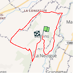
Trail Walking of 9.1 km to be discovered at Fribourg, District de la Glâne, Mézières (FR). This trail is proposed by hgauchat.
Description
Romont-Berlens: 4km , 10min ,
Indemnité km:2.-
Parking:Sur l'esplanade des églises.
Restaurant:Auberge du Pèlerin:026/652.20.80
Curiosité:Chapelle Notre Dame de l'Epine et St. Joseph.
Positioning
Country:
Switzerland
Region :
Fribourg
Department/Province :
District de la Glâne
Municipality :
Mézières (FR)
Location:
Unknown
Start:(Dec)
Start:(UTM)
343517 ; 5173139 (32T) N.
Comments
Trails nearby
![Trail Cycle Mézières (FR) - Berlens - Photo](https://media.geolcdn.com/t/375/260/ext.jpg?maxdim=2&url=https%3A%2F%2Fservices.sitytrail.com%2FGeolivesWS%2FDownloadMedia.ashx%3FTrailID%3D873371%26Media%3D20171207151650.jpg)
![Cycle Cycle](https://static1.geolcdn.com/sitytour/trail-icons/200.png)
Berlens
Cycle
Very easy
Mézières (FR),
Fribourg,
District de la Glâne,
Switzerland
![](/images/other/stat-length.png)
8.5 km | 10.6 km-effort
2h 30min
![](https://static1.geolcdn.com/siteimages/upload/files/16400158638029165_repeat_loop_refresh_sync_direction_icon.png)
Yes
![Trail Cycle Mézières (FR) - Berlens - Photo](https://media.geolcdn.com/t/375/260/ext.jpg?maxdim=2&url=https%3A%2F%2Fservices.sitytrail.com%2FGeolivesWS%2FDownloadMedia.ashx%3FTrailID%3D872972%26Media%3D20171207151650.jpg)
![Cycle Cycle](https://static1.geolcdn.com/sitytour/trail-icons/200.png)
Berlens
Cycle
Very easy
Mézières (FR),
Fribourg,
District de la Glâne,
Switzerland
![](/images/other/stat-length.png)
8.5 km | 10.6 km-effort
2h 30min
![](https://static1.geolcdn.com/siteimages/upload/files/16400158638029165_repeat_loop_refresh_sync_direction_icon.png)
Yes
![Trail Cycle Mézières (FR) - Berlens - Photo](https://media.geolcdn.com/t/375/260/ext.jpg?maxdim=2&url=https%3A%2F%2Fservices.sitytrail.com%2FGeolivesWS%2FDownloadMedia.ashx%3FTrailID%3D872964%26Media%3D20171207151650.jpg)
![Cycle Cycle](https://static1.geolcdn.com/sitytour/trail-icons/200.png)
Berlens
Cycle
Very easy
Mézières (FR),
Fribourg,
District de la Glâne,
Switzerland
![](/images/other/stat-length.png)
8.5 km | 10.6 km-effort
2h 30min
![](https://static1.geolcdn.com/siteimages/upload/files/16400158638029165_repeat_loop_refresh_sync_direction_icon.png)
Yes
![Trail Walking Villorsonnens - Villarsiviriaux Esseiva - Photo](https://media.geolcdn.com/t/375/260/ext.jpg?maxdim=2&url=https%3A%2F%2Fstatic1.geolcdn.com%2Fsiteimages%2Fupload%2Ffiles%2F1553511878bg_sport_marche.png)
![Walking Walking](https://static1.geolcdn.com/sitytour/trail-icons/101.png)
Villarsiviriaux Esseiva
Walking
Medium
Villorsonnens,
Fribourg,
District de la Glâne,
Switzerland
![](/images/other/stat-length.png)
9.4 km | 11.8 km-effort
2h 32min
![](https://static1.geolcdn.com/siteimages/upload/files/16400158638029165_repeat_loop_refresh_sync_direction_icon.png)
Yes
![Trail Walking Mézières (FR) - Berlens 07.12.2017 - Photo](https://media.geolcdn.com/t/375/260/ext.jpg?maxdim=2&url=https%3A%2F%2Fstatic1.geolcdn.com%2Fsiteimages%2Fupload%2Ffiles%2F1553511878bg_sport_marche.png)
![Walking Walking](https://static1.geolcdn.com/sitytour/trail-icons/101.png)
Berlens 07.12.2017
Walking
Easy
Mézières (FR),
Fribourg,
District de la Glâne,
Switzerland
![](/images/other/stat-length.png)
7.8 km | 9.9 km-effort
2h 9min
![](https://static1.geolcdn.com/siteimages/upload/files/16400158638029165_repeat_loop_refresh_sync_direction_icon.png)
Yes
![Trail Walking Villaz - Villaz Esseiva - Photo](https://media.geolcdn.com/t/375/260/ext.jpg?maxdim=2&url=https%3A%2F%2Fstatic1.geolcdn.com%2Fsiteimages%2Fupload%2Ffiles%2F1553511878bg_sport_marche.png)
![Walking Walking](https://static1.geolcdn.com/sitytour/trail-icons/101.png)
Villaz Esseiva
Walking
Easy
Villaz,
Fribourg,
District de la Glâne,
Switzerland
![](/images/other/stat-length.png)
9.6 km | 12 km-effort
2h 35min
![](https://static1.geolcdn.com/siteimages/upload/files/16400158638029165_repeat_loop_refresh_sync_direction_icon.png)
Yes
![Trail Walking Romont (FR) - Romont - Hennens - Prévonloup - Billens - Photo](https://media.geolcdn.com/t/375/260/ext.jpg?maxdim=2&url=https%3A%2F%2Fstatic1.geolcdn.com%2Fsiteimages%2Fupload%2Ffiles%2F1553511878bg_sport_marche.png)
![Walking Walking](https://static1.geolcdn.com/sitytour/trail-icons/101.png)
Romont - Hennens - Prévonloup - Billens
Walking
Very easy
Romont (FR),
Fribourg,
District de la Glâne,
Switzerland
![](/images/other/stat-length.png)
9.8 km | 12.5 km-effort
2h 40min
![](https://static1.geolcdn.com/siteimages/upload/files/16400158638029165_repeat_loop_refresh_sync_direction_icon.png)
Yes
![Trail Walking Villorsonnens - Villarsiviriaux - Massonnens - Villargiroud - Villarsel-le-Gibloux - Villarlod - Photo](https://media.geolcdn.com/t/375/260/ext.jpg?maxdim=2&url=https%3A%2F%2Fstatic1.geolcdn.com%2Fsiteimages%2Fupload%2Ffiles%2F1553511878bg_sport_marche.png)
![Walking Walking](https://static1.geolcdn.com/sitytour/trail-icons/101.png)
Villarsiviriaux - Massonnens - Villargiroud - Villarsel-le-Gibloux - Villarlod
Walking
Easy
Villorsonnens,
Fribourg,
District de la Glâne,
Switzerland
![](/images/other/stat-length.png)
10.6 km | 13.1 km-effort
2h 50min
![](https://static1.geolcdn.com/siteimages/upload/files/16400158638029165_repeat_loop_refresh_sync_direction_icon.png)
Yes